


Naves et Brahic par les châtaigneraie.

dcharbonnier
User
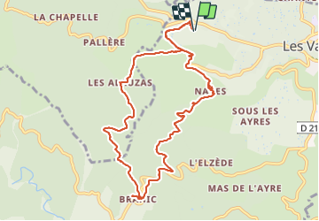

Length
11.8 km

Max alt
592 m

Uphill gradient
540 m
Km-Effort
19 km

Min alt
237 m

Downhill gradient
539 m
Boucle
Yes
Creation date :
2021-09-29 08:19:09.534
Updated on :
2021-09-29 13:40:45.719
5h19
Difficulty : Difficult

FREE GPS app for hiking
 SityTrail
IGN / Geographical institutes
SityTrail Plus
The world is yours!
About
Trail Walking of 11.8 km to be discovered at Auvergne-Rhône-Alpes, Ardèche, Les Vans. This trail is proposed by dcharbonnier.
Description
de calcaire en gneiss et de villages en villages remarquables . Retour par Alauzat et la Serre des cocus.
Positioning
Country:
France
Region :
Auvergne-Rhône-Alpes
Department/Province :
Ardèche
Municipality :
Les Vans
Location:
Naves
Start:(Dec)
Start:(UTM)
588469 ; 4917752 (31T) N.
Comments